

Research Progress
SIA Researchers Make Progress in Sparse‑View Satellite‑Image 3D Reconstruction
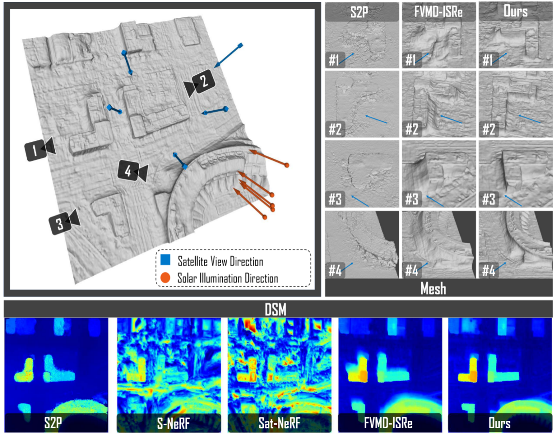
DGR-NeRF effectively reduces shadow artifacts in 3D reconstruction and yields more accurate and complete reconstruction of ground-surface structures. (Image by SIA)
Recovering three-dimensional ground morphology from satellite imagery is a critical foundation for applications such as urban 3D modeling, disaster emergency response, topographic mapping, and digital twins. Typically, 3D reconstruction requires capturing the same area from multiple viewpoints and then inferring the height and shape of ground objects based on discrepancies between different images. However, constrained by satellite orbits and imaging conditions, the effective images available in practical tasks are often limited, and significant variations in illumination and shadow may exist between images.
To address this problem, a research team from the Shenyang Institute of Automation (SIA) of the Chinese Academy of Sciences, has proposed a new satellite-image 3D reconstruction method named DGR-NeRF. The related work was published in the international journal IEEE Transactions on Geoscience and Remote Sensing under the title Depth and Geometry Regularization for Neural Implicit Reconstruction from Few-View Satellite Images. Doctoral student LIU Junyuan from the SIA is the first author, and Researchers SHI Zelin and ZHAO Huaici are the corresponding authors.
A key strength of DGR‑NeRF lies in its performance under sparse‑image inputs. Beyond leveraging visual cues within satellite images, the framework incorporates relative elevation relationships among ground objects and a small set of reliable 3D positional measurements as auxiliary constraints. This drives reconstructed geometry closer to real‑world terrain, boosting both the stability and accuracy of 3D outputs.
In terms of methodology, the team enables different types of information to play their respective roles. On one hand, artificial intelligence is used to infer the approximate depth ordering and relative elevation relationships of ground objects from a single satellite image, helping the model distinguish real terrain from visual variations caused by shadows. On the other hand, a small number of reliable 3D points are extracted from multiple images to provide positional and height references for the entire scene.
Meanwhile, the team added plausibility constraints to the surface generation process to reduce erroneous surfaces, anomalous holes, and similar artifacts. Through these measures, the 3D structures of ground objects such as buildings and roads can be recovered more stably even when input images are scarce.
Rather than simply overlaying data from different sources, the method combines them according to their respective reliable aspects. Image analysis mainly helps determine which areas are higher or lower, the sparse 3D points serve to calibrate overall positioning, and additional constraints help avoid generating obviously implausible structures, thereby mitigating the impact of inaccuracies from any single source of information. The method is particularly well suited to satellite images with pronounced illumination variations and unclear surface textures.
The team validated DGR‑NeRF on two public satellite remote‑sensing datasets. Experimental results demonstrate that the method can reconstruct complete 3D surface morphology with merely five satellite images per scene. In surface‑height accuracy evaluations covering 13 test scenes, DGR‑NeRF attained top performance on 10 scenes and the second‑best results for the remaining three. For 3D‑shape accuracy assessments across 10 scenes, it ranked first in seven scenes and second in three. Tests also confirm that the approach substantially suppresses shadow‑caused faulty geometry and preserves high‑quality reconstruction along building edges and over low‑texture regions.
This research offers an innovative technical pathway for fast, precise retrieval of 3D surface information from limited satellite observations. Rather than relying simply on increasing satellite observation counts, the technique prioritizes mining credible spatial information from sparse input data. It provides solid technical support for urban 3D modelling, rapid disaster‑zone mapping, terrain database updates and other intelligent remote‑sensing applications.

