

Research Progress
Researchers Developed a CAD-Mesher Module for Achieving Accurate Static Map Construction
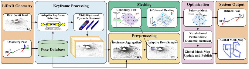
How can mobile robots accurately perceive their environment and construct clear maps in dynamic scenarios such as bustling streets and crowded shopping malls? Recently, a research team from Robotics Laboratory, the Shenyang Institute of Automation (SIA) of the Chinese Academy of Sciences, proposed an innovative solution named CAD-Mesher. This module not only effectively filters out interference from dynamic objects to construct high-precision static mesh maps but can also be conveniently integrated into existing LiDAR systems like a "plug-in," providing new technical support for autonomous navigation of robots in complex dynamic environments.
The research findings have been published in the prestigious international journa IEEE Transactions on Multimedial, titled CAD-Mesher: A Convenient, Accurate, Dense Mesh-Based Mapping Module in SLAM for Dynamic Environments. The first author is graduate student JIA Yanpeng, and the corresponding authors are Researcher WANG Ting and Associate Researcher CAO Fengkui.
Traditional LiDAR SLAM (Simultaneous Localization and Mapping) techniques perform excellently in static environments. However, when confronted with dynamic objects such as pedestrians and vehicles, maps often suffer from "ghosting" or blurred traces, severely impacting robot localization and navigation decision-making. The core innovation of the CAD-Mesher module lies in its unique dynamic object processing mechanism, achieving a leap from "passive recording" to "active filtering."
The research team innovatively designed a two-stage coarse-to-fine dynamic point removal method, marking the first mesh construction approach that explicitly implements dynamic removal. They proposed adaptive keyframe selection and downsampling strategies to ensure the uniformity of point cloud distribution, providing high-quality training data for Gaussian process-based mapping. Furthermore, the team adopted Gaussian process-based incremental mesh construction and point-to-mesh registration optimization methods, eliminating outliers through continuity detection.
Schematic Diagram of Dense Grid Mapping Method for Laser SLAM in Dynamic Environments (Image by SIA)
As a plug-and-play module, CAD-Mesher can be integrated with various LiDAR odometry systems. While enhancing the accuracy of odometry pose estimation, CAD-Mesher incrementally constructs consistent, accurate, and dense static mesh maps, achieving mutual benefits for both localization and mapping.
The research team conducted rigorous testing and comparison on multiple publicly available international datasets, including KITTI and UrbanLoco. Results demonstrate that systems integrated with the CAD-Mesher module surpass current mainstream point cloud-, surfel-, and deep learning-based SLAM methods in both localization accuracy and map construction quality. Particularly in highly dynamic urban streets and complex terrains utilizing sparse-channel LiDAR, CAD-Mesher exhibits exceptional robustness and efficiency.
Characterized by convenience, accuracy, and efficiency, the CAD-Mesher module holds broad application prospects in autonomous navigation and environmental perception for domains such as autonomous ground vehicles, service robots, and industrial mobile robots, providing technical support for the deployment of robots in complex dynamic real-world scenarios.
